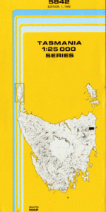
TAS 5842 – Pyengana Hot on Sale
- Estimated Delivery : Up to 4 business days
- Free Shipping & Returns : On all orders over $200
This Topographic Map is produced by the Department of Primary Industries, part of the Tasmanian Government.
These maps are an important resource for Government, industry, and the public. They are used for environmental and emergency management, farm planning and mineral exploration. They are also popular for recreational users such as bushwalkers, mountain bike and horse riders.
The PDF version of this can be printed at home or sent to a professional printer for a 100% scale reproduction.
At this scale, 4cm on this map represents 1km on the ground. A standard map (which is square) covers an area of approximately about 12.5km by 12.5km, with a contour interval of 10m. This map contains natural and constructed features including road and rail infrastructure, vegetation, hydrography, contours, localities and some administrative boundaries.
St Columba Ann Creek Argonaut Creek Barnes Gully Beecheys Bend Billy Of Tin Tier Bog Creek Carters Marsh Clio Hill Constable Creek Coplestones Hill Coromandel Hill Deacons Creek Derwent Creek Erickson Creek Ferntree Falls Ferntree Hill Georges Bay Race Girdys Hill Golden Fleece Rivulet Haleys New Country Hunt Mine Creek Ironbark Falls Kohls Creek Kohls Falls Launceston Creek McAuliffs Hill Moonlight Marsh Morgans Gully Mount Echo Mount Nisbet Nephele Creek Nestor Creek Powers Ridge Powers Rivulet Pyengana Rattrays Flat Rayners Hill Rileys Hill Risky Ridge Royal Ruby Flat Saxelby Creek Siamese Race Siamese Ridge South George River Steels Marsh Strochnetters Hill Suttons Point Terryvale Terryvale Marsh Three Star Creek Toms Gully Yosts Flat Anson Creek Burn Creek Gold Creek Kohls Falls Forest Reserve Long Hill Mount Young Rainforest North George River Bridge Powers Rivulet Bridge Rayners Hill Forest Reserve Tiger Creek Fern Tree Creek
| Title | Pdf Download |
|---|