TAS 5833 – Swansea Online now
- Estimated Delivery : Up to 4 business days
- Free Shipping & Returns : On all orders over $200
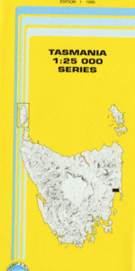
This Topographic Map is produced by the Department of Primary Industries, part of the Tasmanian Government.
These maps are an important resource for Government, industry, and the public. They are used for environmental and emergency management, farm planning and mineral exploration. They are also popular for recreational users such as bushwalkers, mountain bike and horse riders.
The PDF version of this can be printed at home or sent to a professional printer for a 100% scale reproduction.
At this scale, 4cm on this map represents 1km on the ground. A standard map (which is square) covers an area of approximately about 12.5km by 12.5km, with a contour interval of 10m. This map contains natural and constructed features including road and rail infrastructure, vegetation, hydrography, contours, localities and some administrative boundaries.
Rockcliffe Redcliff Cambria Redbanks Piermont Coswell Swansea Dry Creek Dry Creek East Nature Reserve Duncombes Lookout Baldys Bradys Hill Broad Gully Brown Hill Coswell Beach Coswell Beach Conservation Area Cowrie Beach Cressy Beach Cressy Beach Conservation Area Doctors Hills Dolphin Sands Eel Hole Marsh Gills Reef Haywoods Creek Joes Gully Jubilee Beach Kennedia Beach Kings Bridge Lions Park Maysons Bluff Meredith River Merv Lewis Park Nine Mile Beach Piermont Beach Piermont Point Saltwater Creek Sawpit Gully Schouten House Beach Shaw Rivulet Shaws Sugarloaf Smilers Spring Creek Stony River Swansea Conservation Area Triangle Marsh Waterloo Beach Waterloo Point Webber Point West Gully Creek Wet Marsh Bridge Wet Marsh Rivulet Cottons Reef Gull Rock Meredith River Bridge Mount Pleasant Pig Village Shaw Bluff The Four Mile River Stony
| Title | Pdf Download |
|---|