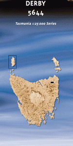
TAS 5644 – Derby Discount
- Estimated Delivery : Up to 4 business days
- Free Shipping & Returns : On all orders over $200
This Topographic Map is produced by the Department of Primary Industries, part of the Tasmanian Government.
These maps are an important resource for Government, industry, and the public. They are used for environmental and emergency management, farm planning and mineral exploration. They are also popular for recreational users such as bushwalkers, mountain bike and horse riders.
The PDF version of this can be printed at home or sent to a professional printer for a 100% scale reproduction.
At this scale, 4cm on this map represents 1km on the ground. A standard map (which is square) covers an area of approximately about 12.5km by 12.5km, with a contour interval of 10m. This map contains natural and constructed features including road and rail infrastructure, vegetation, hydrography, contours, localities and some administrative boundaries.
North Holme Sunny Crest Telita Conley Banks Coranderrk Tara Branxholm Estate Eungella Sunnyside Branxholm Derby Arba Creek Arba Hill Doolan Creek Baker Creek Blackboy Creek Blacksmith Creek Brannan Creek Branxholm Creek Branxholm Station Briseis Hole Briseis Race Brooklyn Creek Brothers Creek Burnies Creek Cascade Dam Cascade River Centenary Park Chid Creek Cream Creek Cross Creek Derby Park Derby Station Emu Flat Emu Hill Farrelly Creek Fiddler Creek Firth Creek Firth Memorial Grove Frasers Flats Frome Dam Frome Hill Frome River Fossil Creek Grays Hill Greenstone Creek Gangforward Creek Gardners Creek Garibaldi Hill Garibaldi Race Gladstone Creek Gloucester Hill Hardmans Hill Harridge Falls Herrick Hibernus Creek Hogan Creek John Dunn Creek Josephs Hill Jubilee Hill Kent Creek Kent Hill Krushka Creek Legerwood Rivulet Linton Creek Little Rio Grande Creek Lohrey Creek Long Bridge Main Creek Mara Creek Moorina Moorina Hill Murrays Lookout Mutual Bridge Mutual Hill Mutual Road Conservation Area Neddy Gore Creek New Find Creek North Eastern Line O K Creek P B Creek Pimlico Creek Pioneer Race Poverty Creek Progress Creek Red Hills Creek Ringarooma River Rock Creek Roopes Creek Rosetta Creek Ruby Flats Sandys Creek Santa Fe Creek Snapper Creek Stella Creek Surrey Lagoon T W T Creek Tallewang Creek The Valley Tin Pot Creek Tyke Creek Valley Creek Valley Pond Valley Race Warrentinna Warrentinna Siding Weld Hill Weld River Wheel Creek Wickborg Creek Wintle Creek Wyniford River York Hill Black Rivulet Bridge Cascade River Bridge Derby Forest Reserve Frome Forest Reserve Frome Rainforest Harridge Rainforest Hursts New Country Legerwood Rivulet Bridge Mara Warrentina Siding Black Creek Legerwood River Weldborough
| Title | Pdf Download |
|---|