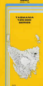
TAS 5640 – Mathinna For Cheap
- Estimated Delivery : Up to 4 business days
- Free Shipping & Returns : On all orders over $200
This Topographic Map is produced by the Department of Primary Industries, part of the Tasmanian Government.
These maps are an important resource for Government, industry, and the public. They are used for environmental and emergency management, farm planning and mineral exploration. They are also popular for recreational users such as bushwalkers, mountain bike and horse riders.
The PDF version of this can be printed at home or sent to a professional printer for a 100% scale reproduction.
At this scale, 4cm on this map represents 1km on the ground. A standard map (which is square) covers an area of approximately about 12.5km by 12.5km, with a contour interval of 10m. This map contains natural and constructed features including road and rail infrastructure, vegetation, hydrography, contours, localities and some administrative boundaries.
Fonthill Mathinna East Tower Black Horse Gully Bowl Creek Chinamens Hill City Of Hobart Spur Cokers Ridge Edwards Creek Eldorado Ridge Fonthill Flat Grassy Hills Griffin Hill Garden Gully Hoggetts Hut Creek Jeromes Lookout Jimmys Creek Jones Lookout Joy Creek Junction Flat Long Gully Creek Lucky Creek Mathinna Rocks McDonalds Flat Midsons Flat Peppermint Hill Rabbitys Creek River Tyne Sheeptail Creek Sling Pot Creek Teds Flat Tims Creek Tower Hill Tower Hill Plantation Tyne Plantation West Tower Winburn Banks Bedding Hill Black Boys Plains Brooks Creek Griffin Forest Reserve Joy Creek Forest Reserve Myrtle Creek Stackyard Gully Tiger Gully Creek