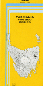
TAS 5638 – Rossarden For Sale
- Estimated Delivery : Up to 4 business days
- Free Shipping & Returns : On all orders over $200
This Topographic Map is produced by the Department of Primary Industries, part of the Tasmanian Government.
These maps are an important resource for Government, industry, and the public. They are used for environmental and emergency management, farm planning and mineral exploration. They are also popular for recreational users such as bushwalkers, mountain bike and horse riders.
The PDF version of this can be printed at home or sent to a professional printer for a 100% scale reproduction.
At this scale, 4cm on this map represents 1km on the ground. A standard map (which is square) covers an area of approximately about 12.5km by 12.5km, with a contour interval of 10m. This map contains natural and constructed features including road and rail infrastructure, vegetation, hydrography, contours, localities and some administrative boundaries.
Tullochgorum Rostrevor Aberfoyle Abbotsford Creek Abbotsford Flat A-One Hill Archer Creek Eastwood Flat Bark Hut Flats Barway Spur Barway Spur Regional Reserve Beans Creek Burns Marsh Burnt Gully Creek Cape Horn Castle Cary Regional Reserve Coachies Marsh Dairy Corner Dalrymple Hill Fehres Marsh Fingal Line Fingal Valley Flapjack Creek Forester Ridge Garth Flat Guts Ache Creek Hogg Hill Iron Pot Gully Jack the Liars Creek Johns Creek Lodge Flats Melrose Creek Mount Clara Mount Edgecumbe Musk Gully Neve Hill Ocky Burns Creek Ormley Redmans Flat Rossarden Rostrevor Rivulet Sawpit Creek Sawpit Ridge Sheepwash Gully Tasmania Creek Top Cottage Green Tower Rivulet Tullochgorum Siding Tullochgorum Creek Vinegar Hill Woodlawn Marsh Burnt Gully Ridge Cat Creek Esk Main Road Bridge Peppermint Hill Rough Hill Sawpit Ridge Forest Reserve Storys Gully Tiger Creek Tullochgorom Creek Bridge Wet Marsh Storeys Creek Story Creek