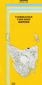
TAS 5045 – Weymouth Cheap
- Estimated Delivery : Up to 4 business days
- Free Shipping & Returns : On all orders over $200
This Topographic Map is produced by the Department of Primary Industries, part of the Tasmanian Government.
These maps are an important resource for Government, industry, and the public. They are used for environmental and emergency management, farm planning and mineral exploration. They are also popular for recreational users such as bushwalkers, mountain bike and horse riders.
The PDF version of this can be printed at home or sent to a professional printer for a 100% scale reproduction.
At this scale, 4cm on this map represents 1km on the ground. A standard map (which is square) covers an area of approximately about 12.5km by 12.5km, with a contour interval of 10m. This map contains natural and constructed features including road and rail infrastructure, vegetation, hydrography, contours, localities and some administrative boundaries.
Weymouth Farm Wingul Bellingham Leura Woodvale Greenburn Weona Greenside Weymouth Back Creek Baker Tier Barrows Hill Bill Toms Gully Emu Ground George Town Council Little Pipers River Conservatio … Majors Creek Pipers Brook Pipers River Poverty Gully Spring Creek Tea Tree Flats Turquoise Bluff Turquoise Creek Wattley Creek Yarrow Creek Bullock Hill Emu Ground Forest Reserve Lefroy Forest Reserve Little Pipers River Bridge Pipers Brook Bridge Pipers River Bridge Ryans Hill Round Hill Little Pipers River Conservation Area Piper River Piper Brook
| Title | Pdf Download |
|---|