TAS 5029 – Kempton Sale
- Estimated Delivery : Up to 4 business days
- Free Shipping & Returns : On all orders over $200
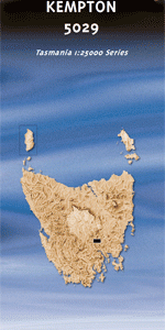
This Topographic Map is produced by the Department of Primary Industries, part of the Tasmanian Government.
These maps are an important resource for Government, industry, and the public. They are used for environmental and emergency management, farm planning and mineral exploration. They are also popular for recreational users such as bushwalkers, mountain bike and horse riders.
The PDF version of this can be printed at home or sent to a professional printer for a 100% scale reproduction.
At this scale, 4cm on this map represents 1km on the ground. A standard map (which is square) covers an area of approximately about 12.5km by 12.5km, with a contour interval of 10m. This map contains natural and constructed features including road and rail infrastructure, vegetation, hydrography, contours, localities and some administrative boundaries.
Tranquillity Woodlands Kelvin Grove Stockman The Follies Belgrave Castle Hill Lonsdale Clifton Vale Mauriceton Oakmore Kempton Astronomers Creek Basin Nature Reserve Basin Tier Beddingdown Hill Belmont Hill Bens Creek Bens Hill Black Tier Bradys Point Brocks Marsh Burnt Marsh Chinas Hill Cross Marsh Creek Curzon Hill Ferny Hills Green Ponds Rivulet Georges Marsh Glenfern Creek Haddens Hill Hunting Ground Irish Valley Johnsons Hill Jordan River Kempton Sugarloaf Langdon Hill Little Quoin Creek Long Bottom Creek Mauriceton Rivulet Melton Mowbray Middle Tier Mosquito Creek Mother Lords Hill Oakmore Hill Old Mans Hill Pat Maguires Hill Racecourse Hill Sag Hill Serpentine Valley Creek Slaters Hill Summerfield Creek Swampy Creek The Basin The Tang Waddles Creek Waddles Creek Conservation Area Wetheron Tier White Banks White Hill Wylies Hill Back White Hill Curzon Downs Quoin Rivulet Bridge Station Park Quoin Rivulet Green Pond Rivulet
| Title | Pdf Download |
|---|