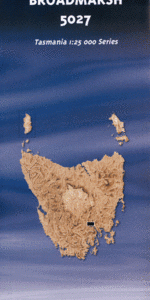
TAS 5027 – Broadmarsh Online Hot Sale
- Estimated Delivery : Up to 4 business days
- Free Shipping & Returns : On all orders over $200
This Topographic Map is produced by the Department of Primary Industries, part of the Tasmanian Government.
These maps are an important resource for Government, industry, and the public. They are used for environmental and emergency management, farm planning and mineral exploration. They are also popular for recreational users such as bushwalkers, mountain bike and horse riders.
The PDF version of this can be printed at home or sent to a professional printer for a 100% scale reproduction.
At this scale, 4cm on this map represents 1km on the ground. A standard map (which is square) covers an area of approximately about 12.5km by 12.5km, with a contour interval of 10m. This map contains natural and constructed features including road and rail infrastructure, vegetation, hydrography, contours, localities and some administrative boundaries.
Arndell Geln Craig Mangalore Farm Leeswood Somerset Strathalie Haeremai Valley Field Hope Vale Marlbrook Oakwood Wybra Hall Braeside Winton Woodlands Nonoyne Bisview Mangalore Abels Marsh Dry Trees Gully Dugalds Hill Ashburton Creek Barnes Gully Big Marsh Billygoat Hill Billys Camp Marsh Black Brush Black Hills Broadmarsh Cherry Tree Rise Cobbs Hill Crooked Billet Creek Davis Hill Deans Hill Gards Hill Genappe Spur Gittus Marsh Goats Hill Hesse Gully Horses Head Jack Jones Gully Lackeys Hill Limekiln Creek Little Hill Little Marsh Lodge Hill Long Bills Creek Mangalore Creek Marsh Creek McShane Hills Millvale Mount Dromedary Murderers Marsh O Connors Flat One O Clock Hill Platform Peak Pritchards Creek Rogerville Siding Scobles Hill Sheepwash Hill Snake Gully Stoneyhurst Creek Strathelie Hill Tanina Tanina Bluff Terrys Hill Upper Dromedary Winton Hill Cornelian Hill Crooked Billet Hoares Corner Mount Dromedary Forest Reserve Portes Corner Ravenswood Bay Tanina Bluff Forest Reserve Mangalore Tier Grahams Creek Dromedary Upper Ravenswood
| Title | Pdf Download |
|---|