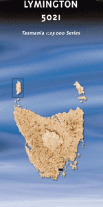
TAS 5021 – Lymington Discount
- Estimated Delivery : Up to 4 business days
- Free Shipping & Returns : On all orders over $200
This Topographic Map is produced by the Department of Primary Industries, part of the Tasmanian Government.
These maps are an important resource for Government, industry, and the public. They are used for environmental and emergency management, farm planning and mineral exploration. They are also popular for recreational users such as bushwalkers, mountain bike and horse riders.
The PDF version of this can be printed at home or sent to a professional printer for a 100% scale reproduction.
At this scale, 4cm on this map represents 1km on the ground. A standard map (which is square) covers an area of approximately about 12.5km by 12.5km, with a contour interval of 10m. This map contains natural and constructed features including road and rail infrastructure, vegetation, hydrography, contours, localities and some administrative boundaries.
Waterlea Beaupre Farm Garden Island Sands Abels Bay Abels Bay Conservation Area Albert Creek Arnolds Creek Arnolds Hill Driftwood Point Drip Beach Echo Sugarloaf Echo Sugarloaf State Reserve Barretts Bay Beaupre Point Birchs Bay Creek Black Jack Ridge Brittains Creek Brooks Bay Burnetts Hill Buxtons Hill Clennett Hills Copper Alley Bay Coulsons Hill Cray Point Cygnet Point Dales Creek Dalys Hill Dears Ridge Deep Bay Deep Bay Creek Deep Bay Point D Entrecasteaux Monument Histor … Desolation Bay Desolation Creek Desolation Point Devils Royals Direens Spur Eggs and Bacon Bay Eggs and Bacon Reef Elizabeths Point Enshaws Gully Eva Gully Fleurtys Creek Flowerpot Flowerpot Rock Forsters Rivulet Granny Gibbons Bay Green Point Garden Island Garden Island Bay Garden Island Creek Garden Island Creek Conservatio … Gardners Bay Gardners Creek Ghost Gully Gordon Gourlays Bay Grosse Creek Grosse Mount Harris Creek Harveys Hill Herlihys Bay Hideaway Bay Holloways Creek Kangaroo Bay Kangaroo Point Kerrs Sugarloaf Killala Bay Langdons Hill Langdons Point Lymington Magpie Hill Mahers Creek Majors Hill McDowall Rivulet McKay Rivulet Merchants Hill Minnie Point Mitchelmore Creek Mount Cygnet Mount Esperance Mount Royal Mount Windsor Mountain Creek Mountain Creek Conservation Area Nicholls Creek Pebble Beach Petcheys Bay Police Point Port Cygnet Poverty Point Purcells Bay Randalls Bay Randalls Bay Conservation Area Range Hill Rocky Bay Rocky Bay Creek Rookwood Creek Sandreef Bay Sandreef Point Sandrock Bay Sandrock Point Shag Point Snake Creek Sunken Rock Bay Thomas Hill Three Hut Point Wheatleys Bay Wheatleys Bay Conservation Area White Bluff Copper Alley Deep Bay Creek Bridge Eggs and Bacon Beach Fleurtys Creek Bridge Foresters Rivulet Bridge Garden Island Creek Bridge Gardeners Bay Bridge Police Point Trig Queen Bay The Pinnacle Gardner Creek Gardener Creek Surges Bay Point Beaupre Point Beaupres Glendevie Point Cygnet South Deep Bay Garden Island Creek Conservation Area DEntrecasteaux Monument Historic Site
| Title | Pdf Download |
|---|