TAS 4644 – Port Sorell Cheap
- Estimated Delivery : Up to 4 business days
- Free Shipping & Returns : On all orders over $200
This Topographic Map is produced by the Department of Primary Industries, part of the Tasmanian Government.
These maps are an important resource for Government, industry, and the public. They are used for environmental and emergency management, farm planning and mineral exploration. They are also popular for recreational users such as bushwalkers, mountain bike and horse riders.
The PDF version of this can be printed at home or sent to a professional printer for a 100% scale reproduction.
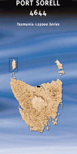
At this scale, 4cm on this map represents 1km on the ground. A standard map (which is square) covers an area of approximately about 12.5km by 12.5km, with a contour interval of 10m. This map contains natural and constructed features including road and rail infrastructure, vegetation, hydrography, contours, localities and some administrative boundaries.
Panatana Banksia Rise Larooma Rubicon Estate Port Sorell Archers Knob Eagle Point Edies Point Asbestos Range Bakers Beach Bakers Point Barretts Lookout Bellions Rock Briggs Creek Briggs Regional Reserve Browns Creek Browns Lookout Budehaven Fenton Creek Fishpond Rocks Flowers Hill Freers Beach Freshwater Creek Griffiths Point Hawley Beach Little Badger Head Little Browns Creek Majors Rocks Marshalls Creek Marshalls Hill Marshalls Point Masseys Creek Narawntapu National Park North East Arm Panatana Rivulet Parkers Ford Penguin Island Point Sorell Point Vision Port Sorell Conservation Area Port Sorell Golf Course Poyston Creek Rabbit Island Rubicon Reserve Scotties Shore Scotts Hill Settlers Hills Shearwater Shearwater Golf Course Sheepwash Creek Sheepwash Hills Shell Islands Springlawn Beach Springlawn Lagoon Spy Island Squeaking Point Squires Gut Stockyard Hills Taroona Point The Carbuncle Watch House Hill West Arm Conservation Area Windred Creek York Town York Town Rivulet Andersons Creek Forest Reserve Big and Little Plain Half Tide Rock Mount Asbestos Point Flinders Sharp Peak Woody Sugarloaf Point Sorrell Port Sorrell Muddy Creek North East Bay Brown Creek
| Title | Pdf Download |
|---|