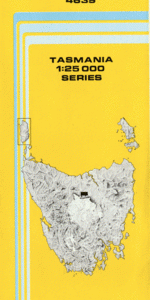
TAS 4639 – Montana For Cheap
- Estimated Delivery : Up to 4 business days
- Free Shipping & Returns : On all orders over $200
This Topographic Map is produced by the Department of Primary Industries, part of the Tasmanian Government.
These maps are an important resource for Government, industry, and the public. They are used for environmental and emergency management, farm planning and mineral exploration. They are also popular for recreational users such as bushwalkers, mountain bike and horse riders.
The PDF version of this can be printed at home or sent to a professional printer for a 100% scale reproduction.
At this scale, 4cm on this map represents 1km on the ground. A standard map (which is square) covers an area of approximately about 12.5km by 12.5km, with a contour interval of 10m. This map contains natural and constructed features including road and rail infrastructure, vegetation, hydrography, contours, localities and some administrative boundaries.
Berkley Ruell Downs Berry Dale Gala Bankton Kinvarra Pleasant Park Ponderosa Allsops Drain Eden Rivulet Barretts Bridge Black Jack Hill Chalkeys Creek Cubits Sugarloaf Dairy Plains Elmers Creek Flinty Rock Golden Valley Kentish Hill Leiths Creek Long Ridge Montana Montana Falls Muddy Creek Native Hop Hill Oven Creek Quamby Brook Spear Hill Stella Glen Stockers Creek Stockers Plains Thompsons Hill Back Marsh Black Jack Hill Forest Reserve Fern Bank Knights Corner Lake Highway Bridge Long Ridge Forest Reserve Mountain Plain Stockers Bottom Tent Creek Tinkers Bog Tower Hill Dale Brook
| Title | Pdf Download |
|---|