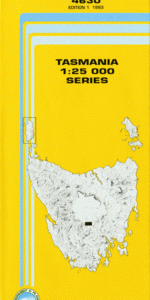
TAS 4630 – Strickland Hot on Sale
- Estimated Delivery : Up to 4 business days
- Free Shipping & Returns : On all orders over $200
This Topographic Map is produced by the Department of Primary Industries, part of the Tasmanian Government.
These maps are an important resource for Government, industry, and the public. They are used for environmental and emergency management, farm planning and mineral exploration. They are also popular for recreational users such as bushwalkers, mountain bike and horse riders.
The PDF version of this can be printed at home or sent to a professional printer for a 100% scale reproduction.
At this scale, 4cm on this map represents 1km on the ground. A standard map (which is square) covers an area of approximately about 12.5km by 12.5km, with a contour interval of 10m. This map contains natural and constructed features including road and rail infrastructure, vegetation, hydrography, contours, localities and some administrative boundaries.
Shawfield Cooma Stockwell Cleveland Glen Dhu Nalya Green Hills Kenmere Wenlock Rotherwood Carinyah Dripstone Hill Dry Hills Dry Hills Creek Drying Ground Ridge Duck Rivulet Dunns Hill Bells Bare Hill Big Snake Hill Black Bobs Black Bobs Rivulet Blackboys Opening Buffers Lookout Bushmans Hill Catagunya Dam Chapmans Hill Cherry Tree Hill Cockatoo Hill Cooma Falls Grassy Hill Glen Dhu Hill Gulf Creek Home Hill Jones Lookout Jungle Creek Lake Catagunya Lanes Tier Locks Hill Paddys Creek Paddys Ridge Ringing Creek Simpsons Creek Strickland Tor Hill Waterloo Hill Wrigleys Flat Arthurs Seat Black Bobs Rivulet Bridge Catagunya Power Station Cleveland Mill Dee River Bridge Pig Tier Pine Row Hill Single Hill The Gulf Wayatinah Forest Reserve Wayatinah Power Station Duck Creek James Lookout Florentine River
| Title | Pdf Download |
|---|