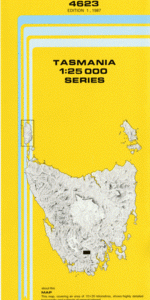
TAS 4623 – Weld Supply
- Estimated Delivery : Up to 4 business days
- Free Shipping & Returns : On all orders over $200
This Topographic Map is produced by the Department of Primary Industries, part of the Tasmanian Government.
These maps are an important resource for Government, industry, and the public. They are used for environmental and emergency management, farm planning and mineral exploration. They are also popular for recreational users such as bushwalkers, mountain bike and horse riders.
The PDF version of this can be printed at home or sent to a professional printer for a 100% scale reproduction.
At this scale, 4cm on this map represents 1km on the ground. A standard map (which is square) covers an area of approximately about 12.5km by 12.5km, with a contour interval of 10m. This map contains natural and constructed features including road and rail infrastructure, vegetation, hydrography, contours, localities and some administrative boundaries.
Eddy Creek Bernard Spur Bovril Creek Camels Back Crystal Creek Fletchers Eddy Fletchers Plain Gallagher Plateau Glovers Bluff Glovers Plain Isabella Creek Kroanna Creek Lobster Lake Looranah Creek Lulworth Spur Manuka Creek Mount Frederick Mount Weld Piners Eddy Reuben Falls Tomalah Creek Trout Lake Truggara Creek Warra Creek Weld Ridge Ken Hill South Weld Forest Reserve Weld Range
| Title | Pdf Download |
|---|