TAS 4427 – Tiger on Sale
- Estimated Delivery : Up to 4 business days
- Free Shipping & Returns : On all orders over $200
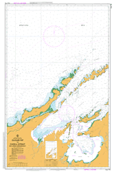
This Topographic Map is produced by the Department of Primary Industries, part of the Tasmanian Government.
These maps are an important resource for Government, industry, and the public. They are used for environmental and emergency management, farm planning and mineral exploration. They are also popular for recreational users such as bushwalkers, mountain bike and horse riders.
The PDF version of this can be printed at home or sent to a professional printer for a 100% scale reproduction.
At this scale, 4cm on this map represents 1km on the ground. A standard map (which is square) covers an area of approximately about 12.5km by 12.5km, with a contour interval of 10m. This map contains natural and constructed features including road and rail infrastructure, vegetation, hydrography, contours, localities and some administrative boundaries.
Abel Creek Adams Bay Adams Falls Adams River Adamsfield Doran Creek Barratt Creek Cain Creek Chrisps Creek Churchill Creek Clear Hill Clear Hill Plain Doak Creek Dome Hill Eve Creek Florentine Gap Football Hill Griffin Creek Gerny Hill Gordon Bend Gordon Gorge Gordon Plains Growling Swallet Honeymead Hill Hopper Creek Humboldt Divide Huntley Rivulet Jeffries Falls Lanham Creek Main Creek Marriott Hill McGillan Creek Moores Gully Mount Field West Myrtle Creek Nanwoon Cave Packers Spur Radcliff Falls Smiths Gully Tassy Pot The Thumbs Tiger Creek Tiger Range Tim Shea Wherretts Lookout Batchelor Creek Card Creek Churchill Spur Gaster Creek Gordon Opening Hayes Gully Huntley Lady Binney Forest Reserve Livingstone Gully Manning Gully North Thumb South Thumb Webster Creek Huntley River Eve River
| Title | Pdf Download |
|---|