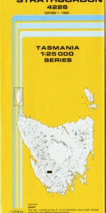
TAS 4226 – Strathgordon Online Hot Sale
- Estimated Delivery : Up to 4 business days
- Free Shipping & Returns : On all orders over $200
This Topographic Map is produced by the Department of Primary Industries, part of the Tasmanian Government.
These maps are an important resource for Government, industry, and the public. They are used for environmental and emergency management, farm planning and mineral exploration. They are also popular for recreational users such as bushwalkers, mountain bike and horse riders.
The PDF version of this can be printed at home or sent to a professional printer for a 100% scale reproduction.
At this scale, 4cm on this map represents 1km on the ground. A standard map (which is square) covers an area of approximately about 12.5km by 12.5km, with a contour interval of 10m. This map contains natural and constructed features including road and rail infrastructure, vegetation, hydrography, contours, localities and some administrative boundaries.
Strathgordon Atkins Range Boyd Island Calder Reach Four O Clock Ridge Junction Range Lake Gordon New Moon Island Picnic Cove Roys Rock Strathgordon Bay Teds Beach Trappes Hill Trappes Inlet Trappes Island Twelvetrees Range White Spur White Spur Point Gilbert Leitch Huon Pine Reserve Observation Hill Adam River
| Title | Pdf Download |
|---|