TAS 4225 – Mcpartlan Fashion
- Estimated Delivery : Up to 4 business days
- Free Shipping & Returns : On all orders over $200
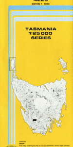
This Topographic Map is produced by the Department of Primary Industries, part of the Tasmanian Government.
These maps are an important resource for Government, industry, and the public. They are used for environmental and emergency management, farm planning and mineral exploration. They are also popular for recreational users such as bushwalkers, mountain bike and horse riders.
The PDF version of this can be printed at home or sent to a professional printer for a 100% scale reproduction.
At this scale, 4cm on this map represents 1km on the ground. A standard map (which is square) covers an area of approximately about 12.5km by 12.5km, with a contour interval of 10m. This map contains natural and constructed features including road and rail infrastructure, vegetation, hydrography, contours, localities and some administrative boundaries.
Hermit Valley Dozer Creek Camel Island Coronation Bay Green Tree Island Gabion Shore Helder Inlet Hermit Basin Hermit Hill Hermit Island Hermit Narrows Hermit Valley Picnic Ground McPartlan Canal McPartlan Pass McPartlan Weir Mount Cullen Mount Helder Sentinel Range Serpentine Island Serpentine Reach Southwest Starfish Islands Stillwater Hill Stillwater Passage Stillwater Picnic Ground Stillwater Rivulet Wedge Inlet Wedge River Wedge River Picnic Ground McPartlan Pass Canal Bridge Mc.Partlands Pass
| Title | Pdf Download |
|---|