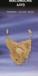
TAS 4223 – Maconochie Sale
- Estimated Delivery : Up to 4 business days
- Free Shipping & Returns : On all orders over $200
This Topographic Map is produced by the Department of Primary Industries, part of the Tasmanian Government.
These maps are an important resource for Government, industry, and the public. They are used for environmental and emergency management, farm planning and mineral exploration. They are also popular for recreational users such as bushwalkers, mountain bike and horse riders.
The PDF version of this can be printed at home or sent to a professional printer for a 100% scale reproduction.
At this scale, 4cm on this map represents 1km on the ground. A standard map (which is square) covers an area of approximately about 12.5km by 12.5km, with a contour interval of 10m. This map contains natural and constructed features including road and rail infrastructure, vegetation, hydrography, contours, localities and some administrative boundaries.
Cinder Hill Corner Peak Dohertys Ground Folded Range Frankland River Greystone Bluff Giblin Bay Hoare Creek Huon Basin Jones Pass Lake Maconochie Lake Surprise Little Cinder Hill Long Ridge McKays Point Mount Giblin Mount Jim Brown Mount Maconochie Pebbly Creek Pine Creek Richardson Creek Right Angle Peak Scrubby Peak Sculptured Mountain Stonehenge Peak Surprise Creek White Monolith Range Wombat Peak Bratts Creek Bratts Pass Flagstaff Hill Marble Towers Secret Amphitheatre Sphinx Rock Survey Platform Frankland Peak Huon Plains
| Title | Pdf Download |
|---|