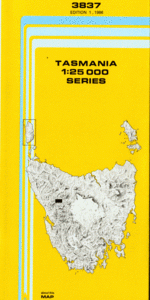
TAS 3837 – Tullah Online Sale
- Estimated Delivery : Up to 4 business days
- Free Shipping & Returns : On all orders over $200
This Topographic Map is produced by the Department of Primary Industries, part of the Tasmanian Government.
These maps are an important resource for Government, industry, and the public. They are used for environmental and emergency management, farm planning and mineral exploration. They are also popular for recreational users such as bushwalkers, mountain bike and horse riders.
The PDF version of this can be printed at home or sent to a professional printer for a 100% scale reproduction.
At this scale, 4cm on this map represents 1km on the ground. A standard map (which is square) covers an area of approximately about 12.5km by 12.5km, with a contour interval of 10m. This map contains natural and constructed features including road and rail infrastructure, vegetation, hydrography, contours, localities and some administrative boundaries.
Tullah Alexandra Hills Alexandra Pass Bruce Creek Central Creek Dalmeny Creek Farrell Creek Farrell Shore Fooks Creek Granite Tor Henry Bay High Tor Lake Herbert Langdon Creek Little Farrell Mount Black Mount Farrell Mount Murchison Mount Murchison Regional Reserve Mount Sale Murchison Bridge Murchison Dam Murchison Gorge Quarry Bay Queens Head Return Ridge Roderick Creek Shaded Lake Sophia Peak Sophia River Sophia Tunnel South Farrell Sterling Inlet Sterling River Sterling Saddle Tunnel End Victoria Peak Bald Hills Central Creek Bridge Fookes Creek Bridge Murchison River Bridge Sterling River Bridge White Hawk Creek Stirling River Murchison River Mackintosh River
| Title | Pdf Download |
|---|