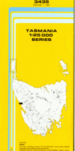
TAS 3435 – Trial Online Sale
- Estimated Delivery : Up to 4 business days
- Free Shipping & Returns : On all orders over $200
This Topographic Map is produced by the Department of Primary Industries, part of the Tasmanian Government.
These maps are an important resource for Government, industry, and the public. They are used for environmental and emergency management, farm planning and mineral exploration. They are also popular for recreational users such as bushwalkers, mountain bike and horse riders.
The PDF version of this can be printed at home or sent to a professional printer for a 100% scale reproduction.
At this scale, 4cm on this map represents 1km on the ground. A standard map (which is square) covers an area of approximately about 12.5km by 12.5km, with a contour interval of 10m. This map contains natural and constructed features including road and rail infrastructure, vegetation, hydrography, contours, localities and some administrative boundaries.
Agnew Creek Eden Creek Bluestone Creek Bridge Creek Colemans Creek Comstock Creek Contiguous Creek Cumberland Creek Cumberland Falls Cumberland Lake Ernies Hill Federation Mine Creek Fen Creek Kynance Creek Little Henty River McLean Creek McLean Falls Montagu Creek Ophir Creek Packers Creek Pulpit Rock Shell Creek South Gap Creek Stonehenge Creek Trial Harbour Trial Harbour State Reserve Wakefield Creek Wheel Bay Badger River Forest Reserve Remine Trial Boat Harbour Powells Siding Firewood Siding Firewood Eden Siding Eden
| Title | Pdf Download |
|---|