GA 9675 – Siri on Sale
- Estimated Delivery : Up to 4 business days
- Free Shipping & Returns : On all orders over $200
This Topographic Map is produced by Geoscience Australia; Australia s national geospatial organisation.
GA topographic maps (many of which are produced in partnership with the Army) are generally older than those maps produced by the State Governments over the same area. This makes GA maps particularly useful for identifying historic features, such as old mines and diggings.
Geoscience Australia maps generally considered to be more pleasing in design and compilation then the more modern State Government productions.
At this scale, 1cm on this map represents 1km on the ground. A standard map (which is square) covers an area of approximately 54km by 54km, with a contour interval of 20m. This map contains natural and constructed features including road and rail infrastructure, vegetation, hydrography, contours, localities and some administrative boundaries.
Please note the date of the map, as this will impact the currency of information, particularly regarding infrastructure, roads, etc.
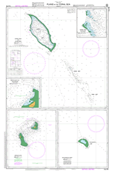
Yambwa Point West Point Venama Island Thenaki Swinger Opening Cape Siri East Point Sudest Rossel Passage Rossell Passage Rossel Lagoon Rambuso Rabuso Creek Proclamation Creek Pawsey Reefs Pawsey Reef Ngea Tree Island Lawik Reef Lamada Point Jivangwa Point Iyuba River Mount Imau Dumaga Bay Deijei Radi Passage Deijei Radi Pass Deiji Radi Pass Johnston Pass Boboa Islet Boboa Island Cape Baganowa Mount Arumbi Arrumbi Fairfax Reefs Tagula TGL Bulawa Rewe Donuwo
| Title | Paper, Laminated |
|---|