TAS 4643 – Harford Fashion
- Estimated Delivery : Up to 4 business days
- Free Shipping & Returns : On all orders over $200
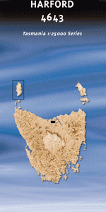
This Topographic Map is produced by the Department of Primary Industries, part of the Tasmanian Government.
These maps are an important resource for Government, industry, and the public. They are used for environmental and emergency management, farm planning and mineral exploration. They are also popular for recreational users such as bushwalkers, mountain bike and horse riders.
The PDF version of this can be printed at home or sent to a professional printer for a 100% scale reproduction.
At this scale, 4cm on this map represents 1km on the ground. A standard map (which is square) covers an area of approximately about 12.5km by 12.5km, with a contour interval of 10m. This map contains natural and constructed features including road and rail infrastructure, vegetation, hydrography, contours, localities and some administrative boundaries.
Seaview Riverview Rhyll Torrington Elphin Grove Andersons Creek Drys Sugarloaf Eagle Gorge Eagle Point Beach East Sassafras Branchs Creek Branchs Creek Plantation Bull Island Coppermine Creek Dalgarth Hill Dans Hill Conservation Area Dazzler Range Finger Point Franklin Rivulet Grass Island Greens Creek Gwins Sugarloaf Harford Holwell Falls Holwell Gorge Holwell Gorge State Reserve Ironstone Hills Kermode Creek Kid Island Lades Tongue Little Branchs Creek Marsh Island Matthews Creek Mount Vulcan Portview Hill Roaring Magg Hill Rubicon Hills Saxons Creek Simmonds Hill South East Arm Sugar Creek Wallaby Creek Bream Creek Coppermine Creek Forest Reserve Dalgarth Forest Reserve Drys New Country Franklin Rivulet Bridge Franklin Rivulet Forest Reserve Greens Ford Longridge Hill Rampers Pass Roaring Magg Hill Forest Reserve Rubicon River Bridge Saxons Creek Bridge The Dazzler The Dazzier Branch Creek Rubicon River Green Creek Deep Creek Franklin River
| Title | Pdf Download |
|---|