PNG 520 – Cape Nelson To Dyke Ackland Bay Online Hot Sale
- Estimated Delivery : Up to 4 business days
- Free Shipping & Returns : On all orders over $200
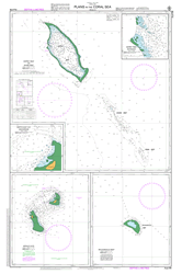
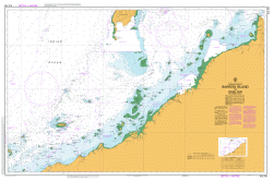
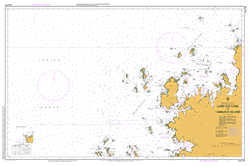
This official Nautical Chart is produced by the Australian Hydrographic Office, and corrected fortnightly to Notice to Marines by Cairns Charts & Maps. This ensures it remains compliance with Safety of Navigation requirements. This marine chart, or sea map , is primarily produced to support the safe navigation of commercial shipping through Australian, Papua New Guinea and Solomon Island waters.
Nautical charts depict the seabed, or bathymetry, using a variety of colours to shade the depth regions. Darker blues indicate shallower water, while light blues and white indicate deeper water. A chart will also show continuous contour lines (at varying intervals depending on the scale of the chart), spot depths across the whole area, as well as different symbols indicating wrecks, shallow rocks and dangers, as well as details on lights, light houses, tides and currents.
For extensive detail on the symbology of nautical charts, the Symbols and Abbreviations used on Admiralty Charts is the definitive reference.
Yupuru River Boboleva Creek Yapuri River Yapuru Creek Wonare River Wonari River Wonare Bay Wakioka River Wajama Inlet Wailou River Wai-Ioa River Wai-Iou River Waijug Mount Victory Keraroa Veale Reef Varau Island Brimaikoroto Island Gowlland Island Uwe River Uwe Creek Uwe Uue Utukwafu Utukwaf Bay Uramanoa Bay Urumanoa Bay Uiaku River UI aku River Uaiku Creek Uiaku Ui-aku Mission Tumina Tumari Tufi Village Tufi Harbour Tufi District Tufi TFI Tremina Creek Mount Trafalgar Iamiwara Totore Creek Tutore Creek Totore Topographers Range Timota Creek The Thumb Teniaru Bay Teniaru Mount Temeraire Muruwe Taruma Tancred Reef Tancred Rock Tamari River Tamari Bay Tainabuna Stewart Reefs Stella Island Spear Island Siu Sinipara Island Hardy Island Sinapara Island Sinipara Sinepara Sinei Sinefada Point Sinapa Point Sinapa Island Sinapa Sinapa Mission Simumu Simoro Bay Sesegara River Sefoa Sefoa Mission Sepoa Mission Sebaga Sarad Mission Wanigela Mission Weniggia Rukapa Lake Ridubidubina Rainu Raboda Creek Rabadi Porlock Harbour Portock Harbour Porlock Bay Ponjari Point Pojari Point Polaris Point Piriseta Phillips Harbour Penari Ovesa Oumo Bay Lake Oumo Oula Creek Orotoaba Oreresan Orersan Onare Island Okeia Point Noukwate Kaibi Naukwate Nelson Range Cape Nelson Natukwaba Naniu Mission Nania Mission Naniu Island Nania Island Musa River Musa Musa Point Moni River Mongna Momoiogo Momoiogu Moiavi Lake Mogana Marua Point Marua Creek Marua Marasa Managa Mamadaborg Mafuia Maclaren Harbour Kofulu Harbour Macharen Harbour Lilioa Leaga Kwin Rest House Kwave Kwapulina Bay Kwafalina Bay Kwapulina Kuruaku Kuririka Kupari Point Sefoa Point Koruwe Koreaf Korala Kopwei River Konedobu Konara River Koje Kikita Keppel Point Katokato Kasiawa Karisoa Karimoa Bay Karaisa Kaparura Kaparuru Kanimeno Point Collinson Point Kaninend Point Kanawetu Kanaweto Wanigela AGL Kamabun Komabun Kakasa Kafera Creek Kabuni Kabubu Kabiabuna Creek Jones Reef Jikuataia Jiguro Island Jebo Iubadi Iu-ai-u River Iu-ai-iu River Yuaiyai Creek Iu-ai-u Iu-ai-iu Uaiku Itoto Point Itoto Creek Itoto Itonomata Ilamororo Ilamaroro Ibura Bay Iba Bay Iagirua Port Hennessy Beribona Bay Hardy Point Ham Reef Hall Point Mount Hall Guruguru Guruga Creek Gugumu Guara Creek Greaves Reef Goia River Gobe Giriwa Gigori Gavida Garrandibut Cecilia Island Ganjiga Gonjige Fuar Founa Fofoma Fona Pofoma Foru River Poru Creek Foru Number 2 Foru Number 1 Foru Foru 2 Foru Mission Fonibaru Foduma Foaru River Poaru Creek Feiaba Bay Esulu Bay Embessa EMS Dyke Ackland Bay Dyke Acland Bay Dudububuna Bay Dove Dove 2 Dobua Point Didana Range Didina Range Dibou River Curtis Reef Collingwood Bay Codys Point Tamina Point Tomino Point Butu Point Mount Britannia Mount Brittania Boyina Creek Boru Bonando River Bonando Point Bonando Berubona 2 Berubona Number 2 Berubona Mission Beribona Beribona Mission Berubona Number 1 Berubona Creek Beribona Creek Beri Bay Bereruma Creek Bendoroda Bekoiana Bei-iata Bai ata Baiata Bauwame Barabara Bambiti Baita Baita Creek Baga Badaide Awainena Creek Awainena Bay Aruoa Bay Araupa Island Aruapa Island Anina River Angorogo Anasari Harbour Anasuri Harbour Anara River Amuioan Amiuan Bay Amuian Bay Biteabout Harbour Lake Ako Lake Aku Ako Aku Ajova River Ilia River Ajova Creek Airara Mission Agaiambo Swamp Agarambo Swamp Afati Bay Tufi Airport AYTU Wanigela Airport AYWG
| Title | Paper, Flat Paper, Laminated |
|---|